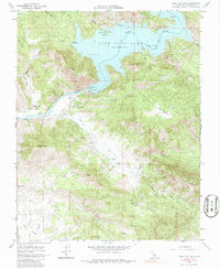
1965 Map of Pine Flat Dam
USGS Topo · Published 1986About this map
The Kings River corridor is defined by the massive engineering of the Pine Flat Dam, a site where the Sierra National Forest and Sequoia National Forest converge. This 1965 survey captures the transition from wilderness to recreation, documenting the Pine Flat Lake at its normal pool elevation of 951 feet. Near the riverbanks, the Pine Flat Dam Hdqrs (USCE) and a Piedra PO indicate the administrative and social center of the local community during the mid-century.
Find a feature on this map
35 named features on this map. Tap any name to fly to it.
Don’t see what you’re looking for? This feature index may not catch every label — zoom into the map to look around manually.
Map Details
Editions of this 1965 Pine Flat Dam Map
3 editions found
Other maps of this area

1920 · Orangedale School
USGS Topo · 1:24,000

1921 · Squaw Valley
USGS Topo · 1:31,680

1922 · Trimmer
USGS Topo · 1:96,000

1923 · Orangedale School
USGS Topo · 1:31,680

1923 · Wahtoke
USGS Topo · 1:31,680

1924 · Citrus Cove
USGS Topo · 1:31,680

1924 · Dinuba
USGS Topo · 1:125,000

1942 · Watts Valley
USGS Topo · 1:62,500

1942 · Dunlap
USGS Topo · 1:62,500

1944 · Watts Valley
USGS Topo · 1:62,500