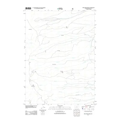
2012 Map of Pine Grove Ridge
USGS Topo · Published 2012About this map
Pine Grove Ridge and Deadline Ridge define the high country of this portion of Sublette County, where a series of prominent east-west ridges separate the drainage basins of numerous mountain creeks. The landscape is marked by a parallel arrangement of topographic features, including Riley Ridge, Reed Ridge, and Trail Ridge, which suggest a complex geological folding. Waterways such as Beaver Cr and Pine Grove Cr cut through the terrain, while Black Canyon Cr flows along the southern reach near Black Canyon Rd. This 2012 survey illustrates the modern access network managed by the Forest Service and BLM, including FS 049 and BLM 5323, which navigate the slopes around Bald Knoll and the various cattle-country canyons. The absence of settlements highlights the primary use of this land for seasonal grazing and resource management within the Bridger-Teton area.
Find a feature on this map
22 named features on this map. Tap any name to fly to it.
Don’t see what you’re looking for? This feature index may not catch every label — zoom into the map to look around manually.
Map Details
Editions of this 2012 Pine Grove Ridge Map
This is the sole edition of this map. No revisions or reprints were ever made.
Other maps of this area

1921 · Afton
USGS Topo · 1:125,000

1936 · Cokeville
USGS Topo · 1:96,000

1939 · Big Piney
USGS Topo · 1:125,000

1942 · Cokeville
USGS Topo · 1:125,000

1942 · Big Piney
USGS Topo · 1:125,000

1955 · Preston
USGS Topo · 1:250,000

1958 · Preston
USGS Topo · 1:250,000

1962 · Preston
USGS Topo · 1:250,000
1967 · Coal Creek
USGS Topo · 1:24,000

1967 · Mount Thompson
USGS Topo · 1:24,000