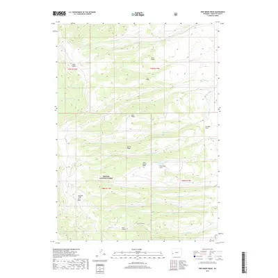
2017 Map of Pine Grove Ridge
USGS Topo · Published 2017About this map
Bridger National Forest defines the southern reach of this landscape, where high ridgelines and deep drainages create a complex topographical network. Distinctive elevations such as Pine Grove Ridge, Deadline Ridge, and Riley Ridge dictate the flow of numerous waterways, including Spring Creek and Beaver Creek. The map shows a transition from these high points into more carved terrain at Black Canyon, which is accessed via Black Canyon Rd. The area's history of logging or resource management is suggested by the naming of Sawmill Creek and South Sawmill Creek, while the prevalence of draws like Dry Basin Draw and Pine Grove Draw illustrates the seasonal water patterns of this Wyoming high-country environment. The survey also captures prominent local landmarks like Bald Knoll and Narrow Ridge, providing a clear look at the region's wilderness character.
Find a feature on this map
28 named features on this map. Tap any name to fly to it.
Don’t see what you’re looking for? This feature index may not catch every label — zoom into the map to look around manually.
Map Details
Editions of this 2017 Pine Grove Ridge Map
This is the sole edition of this map. No revisions or reprints were ever made.
Other maps of this area

1921 · Afton
USGS Topo · 1:125,000

1936 · Cokeville
USGS Topo · 1:96,000

1939 · Big Piney
USGS Topo · 1:125,000

1942 · Cokeville
USGS Topo · 1:125,000

1942 · Big Piney
USGS Topo · 1:125,000

1955 · Preston
USGS Topo · 1:250,000

1958 · Preston
USGS Topo · 1:250,000

1962 · Preston
USGS Topo · 1:250,000
1967 · Coal Creek
USGS Topo · 1:24,000

1967 · Mount Thompson
USGS Topo · 1:24,000