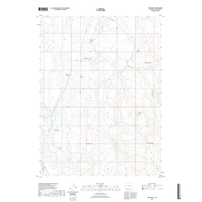
2017 Map of Pine Knoll
USGS Topo · Published 2017About this map
Hilliard Flat and the surrounding high plains of Uinta County are defined by a complex network of man-made water management systems. Long irrigation channels such as the Hilliard Westside Canal, Hilliard E Fork Canal, and Bear Canal snake across the landscape to feed isolated basins like Martin Reservoir and Massae Reservoir. This intricate hydraulic infrastructure reflects the region's historical dependence on redirected water to support ranching and agriculture in an arid environment. Beyond the flats, the terrain rises toward landmarks like Pine Knoll and Rocky Point, while the presence of the Blacks Fork Sheep Trl indicates the area's legacy as a corridor for livestock movement. The map also reveals numerous intermittent drainages like Sulphur Cr and LaChapelle Cr, which intersect with a grid of county roads that provide access to this remote portion of southwestern Wyoming.
Find a feature on this map
34 named features on this map. Tap any name to fly to it.
Don’t see what you’re looking for? This feature index may not catch every label — zoom into the map to look around manually.
Map Details
Editions of this 2017 Pine Knoll Map
This is the sole edition of this map. No revisions or reprints were ever made.
Other maps of this area

1885 · Uinta
USGS Topo · 1:250,000

1901 · Hayden Peak
USGS Topo · 1:125,000

1903 · Hayden Peak
USGS Topo · 1:125,000

1954 · Salt Lake City
USGS Topo · 1:250,000

1954 · Ogden
USGS Topo · 1:250,000

1958 · Ogden
USGS Topo · 1:250,000

1958 · Salt Lake City
USGS Topo · 1:250,000

1960 · Ogden
USGS Topo · 1:250,000

1960 · Salt Lake City
USGS Topo · 1:250,000

1965 · Myers Reservoir
USGS Topo · 1:24,000