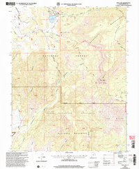
2002 Map of Pine Lake
USGS Topo · Published 2005About this map
Pine Lake serves as a central landmark in this high-altitude landscape of southern Utah, where the boundaries of the Dixie National Forest and the Grand Staircase-Escalante National Monument meet. The geography is defined by the massive Table Cliff Plateau and the sharp descent of the Escalante Mountains, creating a complex network of drainages like Henderson Canyon and Clay Canyon.
Find a feature on this map
41 named features on this map. Tap any name to fly to it.
Don’t see what you’re looking for? This feature index may not catch every label — zoom into the map to look around manually.
Map Details
Editions of this 2002 Pine Lake Map
This is the sole edition of this map. No revisions or reprints were ever made.
Other maps of this area

1886 · Kanab
USGS Topo · 1:250,000

1886 · Escalante
USGS Topo · 1:250,000

1953 · Cedar City
USGS Topo · 1:250,000

1956 · Escalante
USGS Topo · 1:250,000

1958 · Cedar City
USGS Topo · 1:250,000

1960 · Escalante
USGS Topo · 1:250,000

1962 · Cedar City
USGS Topo · 1:250,000

1964 · Griffin Point
USGS Topo · 1:24,000

1964 · Canaan Peak
USGS Topo · 1:24,000

1964 · Henrieville
USGS Topo · 1:24,000