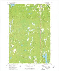
1973 Map of Pine Lake
USGS Topo · Published 1977About this map
Gile Flowage and the surrounding woodlands of northern Wisconsin dominate this landscape, which is split by the township boundaries of Carey and Oma. The area is defined by a heavy timber-and-water economy, evidenced by the numerous Gravel Pits and the Chicago and North Western rail line cutting through the eastern sections. Small settlements like Sandrock and Oma provide a sense of the rural community structure in the 1970s, while recreation sites such as Schomberg County Park and Oma Park highlight the importance of the local lakes. Waterways including the West Fork Montreal River and Laymans Creek create a complex drainage network through the forest. Further south, Pine Lake is a focal point for local navigation and geography, featuring named landmarks like Anchor Island and Paradise Island along with several boat ramps.
Find a feature on this map
37 named features on this map. Tap any name to fly to it.
Don’t see what you’re looking for? This feature index may not catch every label — zoom into the map to look around manually.
Map Details
Editions of this 1973 Pine Lake Map
This is the sole edition of this map. No revisions or reprints were ever made.
Other maps of this area

1940 · Mercer
USGS Topo · 1:48,000

1940 · Butternut
USGS Topo · 1:48,000

1940 · Upson
USGS Topo · 1:48,000

1943 · Upson
USGS Topo · 1:48,000

1943 · Ironwood
USGS Topo · 1:48,000

1945 · Mercer
USGS Topo · 1:48,000

1947 · Butternut
USGS Topo · 1:48,000

1947 · Mercer
USGS Topo · 1:48,000

1950 · Butternut
USGS Topo · 1:48,000

1953 · Ashland
USGS Topo · 1:250,000