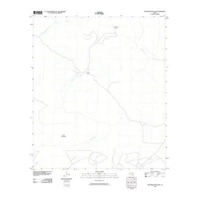
2010 Map of Pine Mountain East
USGS Topo · Published 2010About this map
Pine Mountain stands as a prominent landmark in this sparsely settled region of the West Texas high desert as it appeared in the early 21st century. The landscape is defined by its drainage systems, most notably the winding course of San Francisco Creek and the seasonally dry Guayule Creek which carve through the arid terrain. Human presence is concentrated at the Jones Ranch, which serves as a solitary focal point for ranching operations in a vast area of complex topography. Evidence of the erosive power of local runoff is visible in the etched landforms of Coffee Pot Canyon, illustrating the geological character of Brewster County's remote interior where road networks remain minimal and follow the natural contours of the basin and range province.
Find a feature on this map
5 named features on this map. Tap any name to fly to it.
Don’t see what you’re looking for? This feature index may not catch every label — zoom into the map to look around manually.
Map Details
Editions of this 2010 Pine Mountain East Map
This is the sole edition of this map. No revisions or reprints were ever made.
Other maps of this area

1918 · Dove Mountain
USGS Topo · 1:62,500

1918 · Bullis Gap
USGS Topo · 1:62,500

1920 · Longfellow
USGS Topo · 1:125,000

1954 · Fort Stockton
USGS Topo · 1:250,000

1958 · Fort Stockton
USGS Topo · 1:250,000

1959 · Emory Peak
USGS Topo · 1:250,000

1965 · Emory Peak
USGS Topo · 1:250,000

1968 · Tesnus
USGS Topo · 1:24,000

1968 · Fresno Creek
USGS Topo · 1:24,000
1968 · Tesnus SE
USGS Topo · 1:24,000