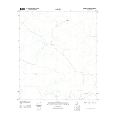
2013 Map of Pine Mountain East
USGS Topo · Published 2013About this map
Jones Ranch sits at the heart of this landscape, marking a solitary point of human habitation amid the expansive terrain of Brewster County. The topography is defined by significant landmarks like the prominent Pine Mtn and the winding course of San Francisco Cr, which cuts through the northern portion of the quadrangle. Drainages such as Guayule Cr carve through the southern reaches, highlighting the drainage patterns typical of this West Texas region. The presence of Coffee Pot Canyon further illustrates the complex relief and natural features that define the area. This 2013 survey provides a clear view of the ranching infrastructure and hydrological systems as they existed in the early 21st century.
Find a feature on this map
5 named features on this map. Tap any name to fly to it.
Don’t see what you’re looking for? This feature index may not catch every label — zoom into the map to look around manually.
Map Details
Editions of this 2013 Pine Mountain East Map
This is the sole edition of this map. No revisions or reprints were ever made.
Other maps of this area

1918 · Dove Mountain
USGS Topo · 1:62,500

1918 · Bullis Gap
USGS Topo · 1:62,500

1920 · Longfellow
USGS Topo · 1:125,000

1954 · Fort Stockton
USGS Topo · 1:250,000

1958 · Fort Stockton
USGS Topo · 1:250,000

1959 · Emory Peak
USGS Topo · 1:250,000

1965 · Emory Peak
USGS Topo · 1:250,000

1968 · Tesnus
USGS Topo · 1:24,000

1968 · Fresno Creek
USGS Topo · 1:24,000
1968 · Tesnus SE
USGS Topo · 1:24,000