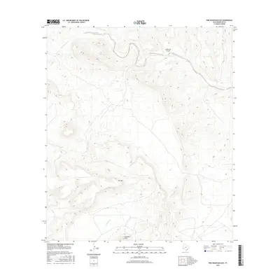
2016 Map of Pine Mountain East
USGS Topo · Published 2016About this map
San Francisco Creek winds through the northern reach of this Brewster County landscape, carving a deep path near Coffee Pot Canyon. The terrain is defined by dramatic elevation shifts, anchored by the prominent rise of Pine Mountain in the central portion of the quadrangle. To the south, Horseshoe Mesa overlooks the drainage of Guayule Creek, illustrating the complex hydrological network of this high-desert environment. This 2016 survey captures the area's physical geography with high-resolution contour data, showing the intricate relationship between steep ridges and the seasonal watercourses that shape the land. While largely unpopulated, the naming of features like Pine Mountain and Horseshoe Mesa points to established landmarks used by ranching interests and early surveyors to navigate this corner of the Trans-Pecos region.
Find a feature on this map
6 named features on this map. Tap any name to fly to it.
Don’t see what you’re looking for? This feature index may not catch every label — zoom into the map to look around manually.
Map Details
Editions of this 2016 Pine Mountain East Map
This is the sole edition of this map. No revisions or reprints were ever made.
Other maps of this area

1918 · Dove Mountain
USGS Topo · 1:62,500

1918 · Bullis Gap
USGS Topo · 1:62,500

1920 · Longfellow
USGS Topo · 1:125,000

1954 · Fort Stockton
USGS Topo · 1:250,000

1958 · Fort Stockton
USGS Topo · 1:250,000

1959 · Emory Peak
USGS Topo · 1:250,000

1965 · Emory Peak
USGS Topo · 1:250,000

1968 · Tesnus
USGS Topo · 1:24,000

1968 · Fresno Creek
USGS Topo · 1:24,000
1968 · Tesnus SE
USGS Topo · 1:24,000