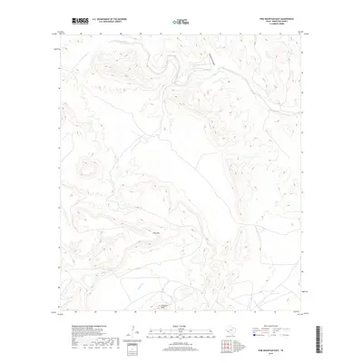
2019 Map of Pine Mountain East
USGS Topo · Published 2019About this map
Pine Mtn and Horseshoe Mesa define the high elevations of this Brewster County landscape, where the terrain is carved by an intricate network of drainage systems. The northern reaches are dominated by the winding course of San Francisco Creek, which is fed by secondary watercourses like Coffee Pot Canyon and San Francisco Cr. These seasonal or intermittent flows suggest a desert environment where water management and topography dictate the local movement and use of the land. In the southern portion of the sheet, Guayule Cr cuts toward the lower elevations, illustrating the persistent erosional patterns that have shaped this portion of West Texas. The scarcity of named structures or settlements emphasizes the undeveloped character of the region during this 2019 survey, focusing instead on the significant natural landforms and the remote nature of the terrain.
Find a feature on this map
6 named features on this map. Tap any name to fly to it.
Don’t see what you’re looking for? This feature index may not catch every label — zoom into the map to look around manually.
Map Details
Editions of this 2019 Pine Mountain East Map
This is the sole edition of this map. No revisions or reprints were ever made.
Other maps of this area

1918 · Dove Mountain
USGS Topo · 1:62,500

1918 · Bullis Gap
USGS Topo · 1:62,500

1920 · Longfellow
USGS Topo · 1:125,000

1954 · Fort Stockton
USGS Topo · 1:250,000

1958 · Fort Stockton
USGS Topo · 1:250,000

1959 · Emory Peak
USGS Topo · 1:250,000

1965 · Emory Peak
USGS Topo · 1:250,000

1968 · Tesnus
USGS Topo · 1:24,000

1968 · Fresno Creek
USGS Topo · 1:24,000
1968 · Tesnus SE
USGS Topo · 1:24,000