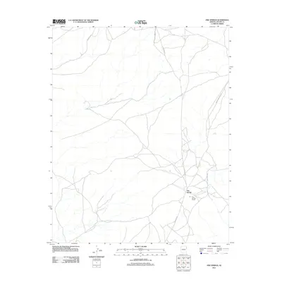
2011 Map of Pine Springs
USGS Topo · Published 2011About this map
Pine Springs serves as the focal point for this 2011 survey of the high plateau region within the Apache County portion of Arizona. The settlement is defined by its rural layout, where local infrastructure is centered around the Pine Springs Airport and the corridor along Indian Rte-2014. The landscape is etched with a network of secondary roads and tribal routes, reflecting a community structured around widely spaced homesteads and essential access points like Pine Springs School Rd. The U.S. Geological Survey mapping reveals a topography of drainage washes and high-elevation terrain, where travel relies on named arteries such as Oak Ridge Rd and Pine Spring Rd to connect the disparate parts of the high desert plateau.
Find a feature on this map
8 named features on this map. Tap any name to fly to it.
Don’t see what you’re looking for? This feature index may not catch every label — zoom into the map to look around manually.
Map Details
Editions of this 2011 Pine Springs Map
This is the sole edition of this map. No revisions or reprints were ever made.
Other maps of this area

1886 · Fort Defiance
USGS Topo · 1:250,000

1892 · Fort Defiance
USGS Topo · 1:250,000

1954 · Gallup
USGS Topo · 1:250,000

1958 · Gallup
USGS Topo · 1:250,000

1959 · Gallup
USGS Topo · 1:250,000

1962 · Gallup
USGS Topo · 1:250,000

1967 · Gallup
USGS Topo · 1:250,000

1971 · Wide Ruins
USGS Topo · 1:24,000

1971 · Burntwater Wash
USGS Topo · 1:24,000
1971 · Joe Woody Well
USGS Topo · 1:24,000