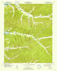
1949 Map of Pine View
USGS Topo · Published 1953About this map
Kentucky Lake defines the western edge of this Tennessee landscape, where the waters of the Tennessee River meet a complex network of hollows and ridges. The small settlement of Pine View sits centrally, surrounded by numerous family-named landmarks and rural institutions that suggest a deeply rooted community. Evidence of local education and faith are scattered throughout the hills, including Nathan Sch, Union Ch, and Dixon Ch.
Find a feature on this map
75 named features on this map. Tap any name to fly to it.
Don’t see what you’re looking for? This feature index may not catch every label — zoom into the map to look around manually.
Map Details
Editions of this 1949 Pine View Map
2 editions found
Other maps of this area

1936 · Pine View
USGS Topo · 1:24,000

1936 · Daniels Landing
USGS Topo · 1:24,000

1936 · Linden
USGS Topo · 1:24,000

1936 · Chestnut Grove
USGS Topo · 1:24,000

1936 · Jeannette
USGS Topo · 1:24,000

1936 · Sugar Tree
USGS Topo · 1:24,000

1936 · Lobelville
USGS Topo · 1:24,000

1936 · Perryville
USGS Topo · 1:24,000

1936 · Pope
USGS Topo · 1:24,000

1949 · Perryville
USGS Topo · 1:24,000