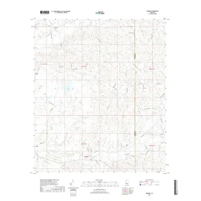
2018 Map of Pinebur
USGS Topo · Published 2018About this map
The community of Pinebur and the nearby settlement of Hub anchor this 2018 survey of the southern Mississippi borderlands between Marion and Lamar Counties. The landscape is defined by an intricate network of waterways, including Upper Little Cr and Lower Little Cr, which drain the timberlands and rural homesteads of the Piney Woods. For genealogists, the map identifies several local burial grounds such as Pinebur Cem, Breakfield Cem, and Cook Cem, providing specific locations for ancestral research in this rural corridor. Several significant bodies of water, including Lake Columbia, Lake Bill Waller, and Lake Watts, suggest a landscape managed for recreation and local industry. The map also records specialized landmarks like Beets Airport and named natural features such as Hollywood Spring, illustrating the persistent naming of even small water sources in the region.
Find a feature on this map
83 named features on this map. Tap any name to fly to it.
Don’t see what you’re looking for? This feature index may not catch every label — zoom into the map to look around manually.
Map Details
Editions of this 2018 Pinebur Map
This is the sole edition of this map. No revisions or reprints were ever made.
Other maps of this area

1953 · Hattiesburg
USGS Topo · 1:250,000

1958 · Hattiesburg
USGS Topo · 1:250,000

1969 · Baxterville SW
USGS Topo · 1:24,000
1969 · Baxterville
USGS Topo · 1:24,000

1969 · Baxterville NE
USGS Topo · 1:24,000

1969 · Pinebur
USGS Topo · 1:24,000

1970 · Columbia South
USGS Topo · 1:24,000

1970 · Columbia North
USGS Topo · 1:24,000
1970 · Sandy Hook
USGS Topo · 1:24,000

1974 · Oloh
USGS Topo · 1:24,000