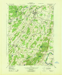
1943 Map of Pinebush
USGS Topo · Published 1944About this map
Pinebush serves as the central hub of this 1940s landscape, positioned near the crossing of the Erie, Middletown and Crawford Branch railroad and the Shawangunk Kill. The map reveals a densely settled agricultural and rural community transitioning into the mid-century, where family names like A. Seeley, W. Porter, and C. Schoonover mark specific homesteads and landholdings. To the south, the Wallkill River snakes toward the Tri-State Airport, while numerous small schools like Brimstone School and Gellabar School suggest the localized nature of rural education at the time.
Find a feature on this map
71 named features on this map. Tap any name to fly to it.
Don’t see what you’re looking for? This feature index may not catch every label — zoom into the map to look around manually.
Map Details
Editions of this 1943 Pinebush Map
This is the sole edition of this map. No revisions or reprints were ever made.
Other maps of this area

1902 · Schunemunk
USGS Topo · 1:62,500

1903 · Newburg
USGS Topo · 1:62,500

1904 · Ellenville
USGS Topo · 1:62,500

1906 · Ellenville
USGS Topo · 1:62,500

1906 · Goshen
USGS Topo · 1:62,500

1908 · Goshen
USGS Topo · 1:62,500

1930 · Schunemunk
USGS Topo · 1:48,000

1935 · Schunemunk
USGS Topo · 1:62,500

1938 · Goshen
USGS Topo · 1:62,500

1942 · Goshen
USGS Topo · 1:24,000