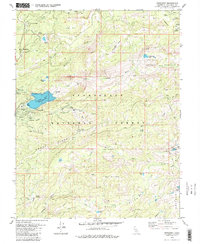
1979 Map of Pinecrest
USGS Topo · Published 1983About this map
Pinecrest and the recreational developments of the mid-1970s anchor this study of the central Sierra Nevada high country. The landscape is defined by the sharp transition from the water-managed shores of Pinecrest Lake to the protected expanse of the Emigrant Wilderness. Evidence of the region’s dual identity as both a timber resource and a seasonal playground is visible in the network of pack trails and early ski lifts on Dodge Ridge.
Find a feature on this map
53 named features on this map. Tap any name to fly to it.
Don’t see what you’re looking for? This feature index may not catch every label — zoom into the map to look around manually.
Map Details
Editions of this 1979 Pinecrest Map
3 editions found
Other maps of this area

1891 · Big Trees
USGS Topo · 1:125,000

1894 · Big Trees
USGS Topo · 1:125,000

1896 · Dardanelles
USGS Topo · 1:125,000

1897 · Big Trees
USGS Topo · 1:125,000

1898 · Dardanelles
USGS Topo · 1:125,000

1901 · Big Trees
USGS Topo · 1:125,000

1947 · Sacramento
USGS Topo · 1:250,000

1948 · Walker Lake
USGS Topo · 1:250,000

1948 · Sacramento
USGS Topo · 1:250,000

1956 · Sacramento
USGS Topo · 1:250,000