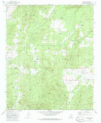
1970 Map of Pinedale
USGS Topo · Published 1985About this map
Sitgreaves National Forest anchors this high-elevation landscape in the Mogollon Rim country of Navajo County. The settlement of Pinedale is clearly defined in the western portion of the sheet, featuring its Ranger Station and nearby Pinedale Spring. To the southeast, the small community of Linden sits along the road to Show Low, while the former lumber site of Standard is preserved as a historical location near Lons Canyon.
Find a feature on this map
70 named features on this map. Tap any name to fly to it.
Don’t see what you’re looking for? This feature index may not catch every label — zoom into the map to look around manually.
Map Details
Editions of this 1970 Pinedale Map
2 editions found
Other maps of this area

1886 · Holbrook
USGS Topo · 1:250,000

1893 · Holbrook
USGS Topo · 1:250,000

1954 · Holbrook
USGS Topo · 1:250,000

1957 · Holbrook
USGS Topo · 1:250,000

1958 · Holbrook
USGS Topo · 1:250,000

1960 · Holbrook
USGS Topo · 1:250,000

1961 · Clay Springs
USGS Topo · 1:62,500
1961 · Show Low
USGS Topo · 1:62,500

1961 · Cibecue
USGS Topo · 1:62,500
1970 · Cactus Flat
USGS Topo · 1:24,000