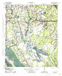
1943 Map of Pineland
USGS Topo · Published 1943About this map
The Southern and Seaboard railroads anchor the rural communities of Jasper and Hampton counties during the early 1940s. Centered around Pineland and the historic settlement of Robertville, this landscape is defined by the expansive Great Swamp and the drainage of the Savannah River along the southwestern border. The map reveals a dense network of country schools and churches that served the agricultural population, including Titi Sch, Newcastle Sch, and Lebanon Ch.
Find a feature on this map
53 named features on this map. Tap any name to fly to it.
Don’t see what you’re looking for? This feature index may not catch every label — zoom into the map to look around manually.
Map Details
Editions of this 1943 Pineland Map
2 editions found

Other maps of this area

1918 · Varnville
USGS Topo · 1:62,500

1918 · Yemassee
USGS Topo · 1:62,500

1919 · Pineland
USGS Topo · 1:62,500

1919 · Shirley
USGS Topo · 1:62,500

1919 · Cummings
USGS Topo · 1:62,500

1919 · Egypt
USGS Topo · 1:62,500

1920 · Hardeeville
USGS Topo · 1:62,500

1920 · Okatie
USGS Topo · 1:62,500

1920 · Peeples
USGS Topo · 1:62,500

1939 · Egypt
USGS Topo · 1:62,500