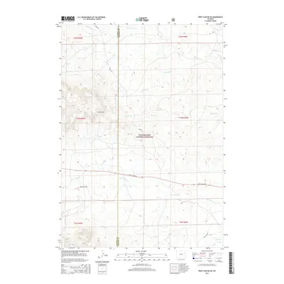
2015 Map of Piney Canyon NE
USGS Topo · Published 2015About this map
Thunder Basin National Grassland dominates this high-plains landscape where the border of Campbell and Weston counties splits the terrain. The topography is defined by a series of drainage basins and ridges, most notably the H A Divide which separates the local headwaters. This 2015 survey reveals a remote ranching and grazing environment where water is the primary geographic anchor, with Black Thunder Cr and Little Thunder Cr cutting through the open country. The road network is sparse, consisting mainly of gravel routes like Keeline Rd and Little Thunder Rd that follow the natural contours of the land. Evidence of the region's physical character is preserved in features like Hansen Draw, illustrating the subtle yet significant relief found in this corner of the Wyoming grasslands.
Find a feature on this map
20 named features on this map. Tap any name to fly to it.
Don’t see what you’re looking for? This feature index may not catch every label — zoom into the map to look around manually.
Map Details
Editions of this 2015 Piney Canyon NE Map
This is the sole edition of this map. No revisions or reprints were ever made.
Other maps of this area

1955 · Newcastle
USGS Topo · 1:250,000

1958 · Newcastle
USGS Topo · 1:250,000

1971 · Piney Canyon NE
USGS Topo · 1:24,000

1971 · Open A Ranch
USGS Topo · 1:24,000

1971 · Piney Canyon SW
USGS Topo · 1:24,000

1971 · Piney Canyon NW
USGS Topo · 1:24,000

1971 · Piney Canyon SE
USGS Topo · 1:24,000
1971 · Buck Creek
USGS Topo · 1:24,000

1974 · Reno Junction
USGS Topo · 1:100,000

1979 · Newcastle
USGS Topo · 1:100,000