
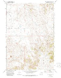
1971 Map of Piney Canyon SW
USGS Topo · Published 1974About this map
High plains energy extraction and cattle ranching define this portion of Campbell County in the early 1970s. The landscape is characterized by a sparse network of natural water sources like Hansen Spring and Red Spring alongside the industrial footprint of numerous Oil Wells and a Strip Mine. This survey captures the transition toward large-scale resource development, with exploratory Drill Holes scattered across the township grid. Infrastructure is limited to essential routes like Piney Canyon Road which navigate the drainage basins of Holman Creek, School Creek, and the West Fork Beckwith Creek. The terrain around Payne shows the complex drainage patterns of the Sunny Draw area, providing a clear view of the topography before decades of intensified mining altered the surface features of the region.
Find a feature on this map
12 named features on this map. Tap any name to fly to it.
Don’t see what you’re looking for? This feature index may not catch every label — zoom into the map to look around manually.
Map Details
Editions of this 1971 Piney Canyon SW Map
2 editions found
Other maps of this area

1955 · Newcastle
USGS Topo · 1:250,000

1958 · Newcastle
USGS Topo · 1:250,000

1959 · Betty Reservoir
USGS Topo · 1:62,500

1971 · Fiddleback Ranch
USGS Topo · 1:24,000

1971 · Coal Bank Draw
USGS Topo · 1:24,000

1971 · Teckla
USGS Topo · 1:24,000

1971 · Piney Canyon NE
USGS Topo · 1:24,000

1971 · Reno Reservoir
USGS Topo · 1:24,000

1971 · Piney Canyon NW
USGS Topo · 1:24,000

1971 · Piney Canyon SE
USGS Topo · 1:24,000