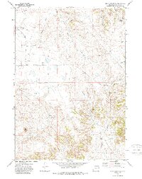
1971 Map of Piney Canyon SW
USGS Topo · Published 1987About this map
Oil wells and drill holes pockmark this Wyoming landscape, indicating the intense energy exploration active in Campbell County during the early 1970s. The terrain is defined by a network of seasonal watercourses and drainages, including Holmes Creek, School Creek, and Hansen Draw. A massive Strip Mine in the southwest corner and a prominent Pipeline cutting across the northern sections highlight the industrial footprint on this ranching country. Transportation is anchored by the Piney Canyon Road, which provides access to the interior of Piney Canyon. Named water sources like Hansen Spring and the West Fork suggest the vital importance of water rights in this semi-arid environment, where surveyors noted numerous fence lines and small stock ponds alongside the industrial development of the era.
Find a feature on this map
16 named features on this map. Tap any name to fly to it.
Don’t see what you’re looking for? This feature index may not catch every label — zoom into the map to look around manually.
Map Details
Editions of this 1971 Piney Canyon SW Map
2 editions found
Other maps of this area

1955 · Newcastle
USGS Topo · 1:250,000

1958 · Newcastle
USGS Topo · 1:250,000

1959 · Betty Reservoir
USGS Topo · 1:62,500

1971 · Fiddleback Ranch
USGS Topo · 1:24,000

1971 · Coal Bank Draw
USGS Topo · 1:24,000

1971 · Teckla
USGS Topo · 1:24,000

1971 · Piney Canyon NE
USGS Topo · 1:24,000

1971 · Reno Reservoir
USGS Topo · 1:24,000

1971 · Piney Canyon SW
USGS Topo · 1:24,000

1971 · Piney Canyon NW
USGS Topo · 1:24,000