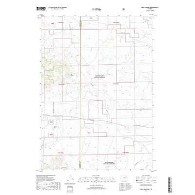
2017 Map of Piney Canyon NE
USGS Topo · Published 2017About this map
Thunder Basin National Grassland dominates the landscape of this high plains region, where the county line between Campbell and Weston counties runs through a network of seasonal drainages and topographic divides. The area is defined by its water systems, notably Little Thunder Creek and Black Thunder Creek, which carve through the open range. Local geography is marked by the H A Divide and Hansen Draw, indicating a terrain where subtle elevation changes dictate the flow of several creeks including Little Mike Creek and Buzzard Creek. Transport in this part of Wyoming relies on ranch roads like Keeline Road and Little Thunder Road, which provide the primary access through the public grassland and private land holdings during the early twenty-first century.
Find a feature on this map
21 named features on this map. Tap any name to fly to it.
Don’t see what you’re looking for? This feature index may not catch every label — zoom into the map to look around manually.
Map Details
Editions of this 2017 Piney Canyon NE Map
This is the sole edition of this map. No revisions or reprints were ever made.
Other maps of this area

1955 · Newcastle
USGS Topo · 1:250,000

1958 · Newcastle
USGS Topo · 1:250,000

1971 · Piney Canyon NE
USGS Topo · 1:24,000

1971 · Open A Ranch
USGS Topo · 1:24,000

1971 · Piney Canyon SW
USGS Topo · 1:24,000

1971 · Piney Canyon NW
USGS Topo · 1:24,000

1971 · Piney Canyon SE
USGS Topo · 1:24,000
1971 · Buck Creek
USGS Topo · 1:24,000

1974 · Reno Junction
USGS Topo · 1:100,000

1979 · Newcastle
USGS Topo · 1:100,000