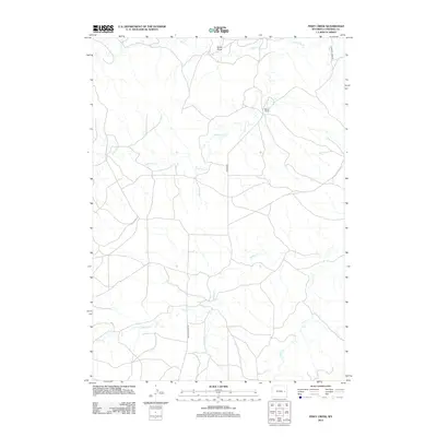
2012 Map of Piney Creek
USGS Topo · Published 2012About this map
Moore Ranch sits as a primary marker of habitation within this drainage-heavy landscape of Converse County. The area is defined by a dendritic network of seasonal waterways, including the winding course of Lightning Cr and the namesake Piney Cr in the southeast. These water features, alongside Walker Cr, Willow Cr, and Box Cr, reveal the natural contours of the High Plains ranching country. Transportation is centered on rural routes such as Walker Creek Rd and Moore Rd, which provide access to the remote landholdings and terrain features like Colter Draw. The map illustrates the sparsely populated nature of the region, where roads primarily serve to connect ranching operations to the broader geography of eastern Wyoming.
Find a feature on this map
9 named features on this map. Tap any name to fly to it.
Don’t see what you’re looking for? This feature index may not catch every label — zoom into the map to look around manually.
Map Details
Editions of this 2012 Piney Creek Map
This is the sole edition of this map. No revisions or reprints were ever made.
Other maps of this area

1954 · Torrington
USGS Topo · 1:250,000

1955 · Newcastle
USGS Topo · 1:250,000

1958 · Torrington
USGS Topo · 1:250,000

1958 · Newcastle
USGS Topo · 1:250,000

1970 · Bill 4 SE
USGS Topo · 1:24,000

1970 · Walker Creek School
USGS Topo · 1:24,000

1970 · Bill 4 NW
USGS Topo · 1:24,000

1970 · Lost Springs NW
USGS Topo · 1:24,000
1970 · Bill 4 SW
USGS Topo · 1:24,000
1970 · Simpson Draw NW
USGS Topo · 1:24,000