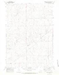
1970 Map of Simpson Draw NW
USGS Topo · Published 1973About this map
Lebar Ranch and the small settlement of Lebar anchor this rural landscape in Converse County at the dawn of the 1970s. The terrain is defined by the intricate branching of Walker Creek, including the West Fork and South Fork, which carve through the high plains. A single Pipeline and scattered markers like a Drill Hole suggest the industrial presence and energy exploration occurring in the region during this era. The map records a sparsely populated ranching territory where local infrastructure is limited to unimproved roads and a few key water sources such as Willow Creek. It offers a clear view of the mid-century land use in a corner of Wyoming before more modern developments changed the character of these ranch holdings.
Find a feature on this map
11 named features on this map. Tap any name to fly to it.
Don’t see what you’re looking for? This feature index may not catch every label — zoom into the map to look around manually.
Map Details
Editions of this 1970 Simpson Draw NW Map
This is the sole edition of this map. No revisions or reprints were ever made.
Other maps of this area

1949 · Clausen Ranch
USGS Topo · 1:24,000

1949 · Antelope Creek
USGS Topo · 1:24,000

1950 · Clausen Ranch
USGS Topo · 1:24,000
1950 · Antelope Creek
USGS Topo · 1:24,000

1954 · Torrington
USGS Topo · 1:250,000

1955 · Newcastle
USGS Topo · 1:250,000

1958 · Torrington
USGS Topo · 1:250,000

1958 · Newcastle
USGS Topo · 1:250,000

1959 · Bill
USGS Topo · 1:62,500
1970 · The Park
USGS Topo · 1:24,000