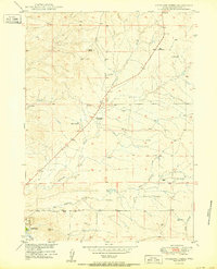
1950 Map of Antelope Creek
USGS Topo · Published 1950About this map
Antelope Creek and its tributary East Antelope Creek wind through the rangeland of Converse County in this 1950 survey, conducted as part of the Department of the Interior's Missouri River Basin development program. The landscape is defined by isolated ranching operations and the necessary infrastructure of the high plains, including numerous Windmill sites and the Highland Loop Road. A small portion of Douglas appears in the southwest corner, marked with a Cem and local structures. Further north, the presence of the Graves School (Abandoned) along the main thoroughfare provides a window into the changing settlement patterns of the era, where once-active rural schoolhouses began to fall into disuse. Family names like those at Combs Ranch and Wallis Ranch identify the primary landholdings that anchored this sparsely populated agricultural district during the mid-twentieth century.
Find a feature on this map
15 named features on this map. Tap any name to fly to it.
Don’t see what you’re looking for? This feature index may not catch every label — zoom into the map to look around manually.
Map Details
Editions of this 1950 Antelope Creek Map
This is the sole edition of this map. No revisions or reprints were ever made.
Other maps of this area

1949 · Sundquist Ranch
USGS Topo · 1:24,000

1949 · Irvine
USGS Topo · 1:24,000

1949 · Douglas
USGS Topo · 1:24,000

1949 · Chalk Buttes
USGS Topo · 1:24,000

1949 · Clausen Ranch
USGS Topo · 1:24,000

1949 · Orin
USGS Topo · 1:24,000

1949 · Antelope Creek
USGS Topo · 1:24,000

1950 · Clausen Ranch
USGS Topo · 1:24,000

1950 · Douglas
USGS Topo · 1:24,000

1950 · Orin
USGS Topo · 1:24,000