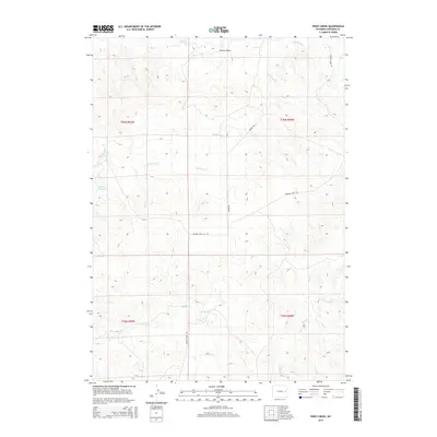
2015 Map of Piney Creek
USGS Topo · Published 2015About this map
Lightning Cr and its various tributaries, including Box Cr and Walker Cr, carve a complex drainage system through this portion of Converse County. The land is largely defined by this network of ephemeral and perennial streams, with Colter Draw providing a distinct break in the northern topography. Human presence is evidenced primarily by the ranch roads and water management features necessary for life in this arid environment, most notably at the Werner Reservoir in the west. This 2015 survey illustrates how contemporary land use remains tied to the natural watercourses, with Walker Creek Rd and Moore Rd following the terrain's logic. The map also clearly delineates the Public Land Survey System boundaries, specifically the intersection of Townships 35 and 36 North across Ranges 68 and 69 West, providing a precise spatial framework for modern land ownership and historical tracking.
Find a feature on this map
13 named features on this map. Tap any name to fly to it.
Don’t see what you’re looking for? This feature index may not catch every label — zoom into the map to look around manually.
Map Details
Editions of this 2015 Piney Creek Map
This is the sole edition of this map. No revisions or reprints were ever made.
Other maps of this area

1954 · Torrington
USGS Topo · 1:250,000

1955 · Newcastle
USGS Topo · 1:250,000

1958 · Torrington
USGS Topo · 1:250,000

1958 · Newcastle
USGS Topo · 1:250,000

1970 · Bill 4 SE
USGS Topo · 1:24,000

1970 · Walker Creek School
USGS Topo · 1:24,000

1970 · Bill 4 NW
USGS Topo · 1:24,000

1970 · Lost Springs NW
USGS Topo · 1:24,000
1970 · Bill 4 SW
USGS Topo · 1:24,000
1970 · Simpson Draw NW
USGS Topo · 1:24,000