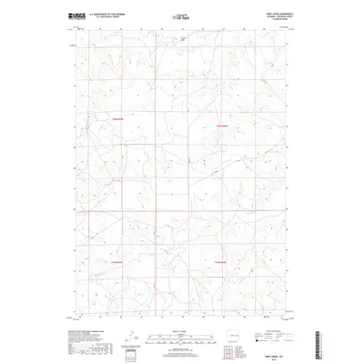
2017 Map of Piney Creek
USGS Topo · Published 2017About this map
Piney Creek and its neighboring drainage systems define this section of Converse County, where the high plains terrain is etched by seasonal watercourses and draws. The map illustrates a landscape structured by the Public Land Survey System, specifically within Townships t36n r69w and t36n r68w, where early 21st-century ranching roads like Moore Rd and Co Rd 43 provide the primary access through the undulating country. Significant topographical features such as Colter Draw and the winding paths of Lightning Cr and Walker Cr indicate the natural drainage patterns that have likely influenced land use and grazing boundaries for generations. This survey provides researchers a precise look at the rural infrastructure and hydraulic geography of the area, capturing the sparse but essential road network that connects these disparate Wyoming watersheds.
Find a feature on this map
12 named features on this map. Tap any name to fly to it.
Don’t see what you’re looking for? This feature index may not catch every label — zoom into the map to look around manually.
Map Details
Editions of this 2017 Piney Creek Map
This is the sole edition of this map. No revisions or reprints were ever made.
Other maps of this area

1954 · Torrington
USGS Topo · 1:250,000

1955 · Newcastle
USGS Topo · 1:250,000

1958 · Torrington
USGS Topo · 1:250,000

1958 · Newcastle
USGS Topo · 1:250,000

1970 · Bill 4 SE
USGS Topo · 1:24,000

1970 · Walker Creek School
USGS Topo · 1:24,000

1970 · Bill 4 NW
USGS Topo · 1:24,000

1970 · Lost Springs NW
USGS Topo · 1:24,000
1970 · Bill 4 SW
USGS Topo · 1:24,000
1970 · Simpson Draw NW
USGS Topo · 1:24,000