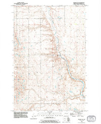
1990 Map of Pingree SW
USGS Topo · Published 1995About this map
Pipestem Creek meanders through the central and southern sections of this landscape, forming a primary hydrological artery for this corner of Stutsman County. The terrain is characterized by distinct regional landforms such as Round Top in the northwest and the broader elevations of Plainview and Hidden. These labels reflect a topography shaped by glacial activity, with numerous small depressions and seasonal basins scattered across the high plains. A Gaging Station located along the creek bank provides a specific point of historical data collection for water management in the region. The map preserves the 1950s survey foundations with 1990 imagery revisions, showing the persistent section lines and township boundaries of T 142 N and T 141 N that define North Dakota's rural grid system.
Find a feature on this map
6 named features on this map. Tap any name to fly to it.
Don’t see what you’re looking for? This feature index may not catch every label — zoom into the map to look around manually.
Map Details
Editions of this 1990 Pingree SW Map
This is the sole edition of this map. No revisions or reprints were ever made.
Other maps of this area

1896 · Jamestown
USGS Topo · 1:125,000

1900 · Pingree
USGS Topo · 1:125,000

1900 · Pingree
USGS Topo · 1:62,500

1950 · Buchanan
USGS Topo · 1:24,000

1951 · Pingree
USGS Topo · 1:24,000

1951 · Eldridge NW
USGS Topo · 1:24,000

1952 · Buchanan
USGS Topo · 1:24,000

1952 · Eldridge
USGS Topo · 1:24,000

1952 · Jim Lake
USGS Topo · 1:24,000

1952 · Pingree SW
USGS Topo · 1:24,000