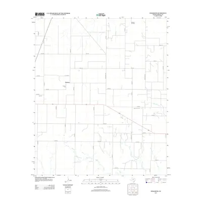
2012 Map of Pinkerton
USGS Topo · Published 2012About this map
Pinkerton serves as the focal point of this Haskell County landscape, characterized by a grid of county roads and ranch routes that define the local agricultural and industrial footprint. The energy sector is prominent in this northern Texas territory, with the Weinert Oil Field and Sojourner Oil Field marked across the plains. Natural drainage is shaped by the winding courses of Mule Cr and N Mule Cr, which lead toward the distinct basin of Bitter Lake in the southern portion of the quadrangle. For those researching local heritage, the map identifies the Pinkerton Cem and Rule Cem, providing specific locations for these rural burial grounds. The transport network, including Ranch Road 2407 and Ranch Road 2163, highlights the connectivity between scattered homesteads and the larger regional hubs.
Find a feature on this map
40 named features on this map. Tap any name to fly to it.
Don’t see what you’re looking for? This feature index may not catch every label — zoom into the map to look around manually.
Map Details
Editions of this 2012 Pinkerton Map
This is the sole edition of this map. No revisions or reprints were ever made.
Other maps of this area

1925 · Haskell 3-b
USGS Topo · 1:48,000

1954 · Wichita Falls
USGS Topo · 1:250,000

1958 · Wichita Falls
USGS Topo · 1:250,000

1964 · Sagerton
USGS Topo · 1:24,000

1965 · Jud
USGS Topo · 1:24,000

1966 · Haskell
USGS Topo · 1:24,000
1966 · Dudleys Creek
USGS Topo · 1:24,000
1966 · Pinkerton
USGS Topo · 1:24,000
1966 · Lake Stamford West
USGS Topo · 1:24,000

1967 · Rochester
USGS Topo · 1:24,000