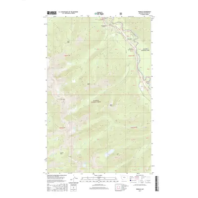
2017 Map of Pinnacle
USGS Topo · Published 2017About this map
John F Stevens Canyon and the Theodore Roosevelt Pass serve as the primary conduits through the high elevations of the Flathead Range on this 2017 survey. The landscape is defined by the sharp transition between the Flathead National Forest and Glacier National Park, with the Middle Fork Flathead River carving a deep boundary between them. The small settlement of Pinnacle sits near the river, shadowed by peaks like Elk Mtn and Essex Mtn. This area reflects the modern infrastructure required to traverse the Continental Divide, evidenced by Tunnel Number 2 and Tunnel Number 3 along the rail corridor. High-altitude water bodies, including Marion Lake, Dickey Lake, and Almeda Lake, are scattered throughout the drainages of Paola Cr and Essex Cr, marking the complex hydrology of this mountainous Montana wilderness.
Find a feature on this map
38 named features on this map. Tap any name to fly to it.
Don’t see what you’re looking for? This feature index may not catch every label — zoom into the map to look around manually.
Map Details
Editions of this 2017 Pinnacle Map
This is the sole edition of this map. No revisions or reprints were ever made.
Other maps of this area

1914 · Nyack
USGS Topo · 1:125,000

1958 · Nimrod
USGS Topo · 1:24,000

1958 · Felix Peak
USGS Topo · 1:24,000

1960 · Cut Bank
USGS Topo · 1:250,000

1963 · Cut Bank
USGS Topo · 1:250,000

1964 · Cut Bank
USGS Topo · 1:250,000

1964 · Essex
USGS Topo · 1:24,000

1964 · Nyack
USGS Topo · 1:24,000

1964 · Pinnacle
USGS Topo · 1:24,000

1964 · Stanton Lake
USGS Topo · 1:24,000