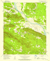
1954 Map of Pinnacle Mountain
USGS Topo · Published 1957About this map
Pinnacle Mountain and the surrounding Fulk Mountains dominate the horizon west of Little Rock in this mid-1950s survey. The Arkansas River serves as the primary geographic corridor, flanked by the Missouri Pacific and Chicago Rock Island and Pacific railroads. The landscape reveals a complex mix of mid-century infrastructure and rural community life, featuring the sprawling Maumelle Ordnance Works and the Pulaski-County Prison Farm alongside long-established settlements like Natural Steps and the Pankey Addition. Researchers will find a high density of local landmarks, from the Joe T Robinson School to numerous country congregations including Nalls Memorial Church and Mountain View Church. The inclusion of the State Hospital and various family-named cemeteries such as Grimmette Cemetery and Aaron Cemetery provide significant genealogical value for the region before extensive modern suburban expansion.
Find a feature on this map
54 named features on this map. Tap any name to fly to it.
Don’t see what you’re looking for? This feature index may not catch every label — zoom into the map to look around manually.
Map Details
Editions of this 1954 Pinnacle Mountain Map
This is the sole edition of this map. No revisions or reprints were ever made.
Other maps of this area

1890 · Benton
USGS Topo · 1:125,000

1891 · Little Rock
USGS Topo · 1:125,000

1893 · Little Rock
USGS Topo · 1:125,000

1894 · Benton
USGS Topo · 1:125,000

1935 · Little Rock
USGS Topo · 1:24,000

1935 · North Little Rock
USGS Topo · 1:24,000

1935 · Alexander
USGS Topo · 1:48,000

1938 · Benton
USGS Topo · 1:48,000

1941 · Alexander
USGS Topo · 1:62,500

1943 · Pinnacle Mtn
USGS Topo · 1:31,680