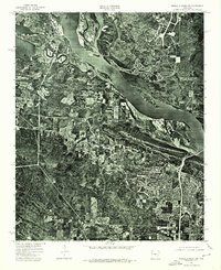
1975 Map of Pinnacle Mountain
USGS Topo · Published 1976About this map
Pinnacle Mountain stands as a prominent landmark in this 1975 orthophotomap, which captures the transition between the rising terrain and the broad river valley of central Arkansas. The imagery, derived from high-altitude aerial photography, clearly defines the confluence where the Maumelle River joins the much larger Arkansas River. This perspective reveals the dense forests of the mountain slopes set against the expanding suburban residential patterns emerging south of the river during the mid-1970s. The survey illustrates the relationship between the natural geography of the river's winding course and the intensifying land development along the transportation corridors that connect this area to the state's capital region.
Find a feature on this map
3 named features on this map. Tap any name to fly to it.
Don’t see what you’re looking for? This feature index may not catch every label — zoom into the map to look around manually.
Map Details
Editions of this 1975 Pinnacle Mountain Map
This is the sole edition of this map. No revisions or reprints were ever made.
Other maps of this area

1890 · Benton
USGS Topo · 1:125,000

1891 · Little Rock
USGS Topo · 1:125,000

1893 · Little Rock
USGS Topo · 1:125,000

1894 · Benton
USGS Topo · 1:125,000

1935 · Little Rock
USGS Topo · 1:24,000

1935 · North Little Rock
USGS Topo · 1:24,000

1935 · Alexander
USGS Topo · 1:48,000

1938 · Benton
USGS Topo · 1:48,000

1941 · Alexander
USGS Topo · 1:62,500

1943 · Pinnacle Mtn
USGS Topo · 1:31,680