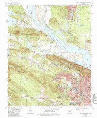
1986 Map of Pinnacle Mountain
USGS Topo · Published 1986About this map
Pinnacle Mountain rises as a prominent landmark near the confluence of the Little Maumelle River and the Arkansas River, anchoring the landscape of Pinnacle Mountain State Park. In the mid-1980s, this area of Pulaski County reveals a mix of suburban expansion and industrial footprints, with residential developments like Maumelle and Woodland Heights encroaching upon older rural settlements such as Natural Steps and Pankey. The map captures the infrastructure supporting the growth of Little Rock, including the Aqueduct and various waterworks.
Find a feature on this map
75 named features on this map. Tap any name to fly to it.
Don’t see what you’re looking for? This feature index may not catch every label — zoom into the map to look around manually.
Map Details
Editions of this 1986 Pinnacle Mountain Map
This is the sole edition of this map. No revisions or reprints were ever made.
Other maps of this area

1890 · Benton
USGS Topo · 1:125,000

1891 · Little Rock
USGS Topo · 1:125,000

1893 · Little Rock
USGS Topo · 1:125,000

1894 · Benton
USGS Topo · 1:125,000

1935 · Little Rock
USGS Topo · 1:24,000

1935 · North Little Rock
USGS Topo · 1:24,000

1935 · Alexander
USGS Topo · 1:48,000

1938 · Benton
USGS Topo · 1:48,000

1941 · Alexander
USGS Topo · 1:62,500

1943 · Pinnacle Mtn
USGS Topo · 1:31,680