
1964 Map of Pinon Hills
USGS Topo · Published 1967About this map
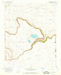
The rugged topography of the Piñon Hills dominates this mid-1960s Colfax County landscape, illustrating a transition from the elevated peaks into the broader high plains. A significant portion of this terrain lies within the historic Beaubien and Miranda (Maxwell) land grant, reflecting the area's deep-rooted ranching and land tenure history. Water management and transport are key themes of the survey, with the Charette Lake Canal cutting across the southern reaches while Salado Creek winds through the northern flats. The eastern edge of the quadrangle is defined by the critical corridor of the Atchison Topeka and Santa Fe railroad, which provided the vital transport link for this region’s agricultural and mineral output. Industrial activity is noted by a Gravel Pit near the northern boundary, while a solitary Spring provides a vital water source in the western hills.
Find a feature on this map
8 named features on this map. Tap any name to fly to it.
Don’t see what you’re looking for? This feature index may not catch every label — zoom into the map to look around manually.
Map Details
Editions of this 1964 Pinon Hills Map
This is the sole edition of this map. No revisions or reprints were ever made.
Other maps of this area

1954 · Raton
USGS Topo · 1:250,000

1956 · Miami
USGS Topo · 1:62,500

1958 · Raton
USGS Topo · 1:250,000

1964 · Stony Lake
USGS Topo · 1:24,000

1964 · Colmor
USGS Topo · 1:24,000

1965 · French
USGS Topo · 1:24,000

1965 · Springer Lake
USGS Topo · 1:24,000

1965 · Springer
USGS Topo · 1:24,000
1966 · Charette Lake
USGS Topo · 1:24,000

1981 · Springer
USGS Topo · 1:100,000