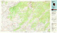
1983 Map of Pinon
USGS Topo · Published 1983About this map
The expansive High Plateau of northern Arizona is dominated by the massive Black Mesa and its complex network of washes and canyons. This 1983 survey illustrates the shared geography of the Navajo Indian Reservation and the Hopi Indian Reservation, showing the sparse settlement patterns of Pinon, Rough Rock, and Cow Springs. The map reveals a landscape defined by seasonal water sources and geological landmarks, from the Elephant Feet rock formations in the northwest to the dramatic White Ruin Canyon. The influence of modern infrastructure is visible through the Black Mesa and Lake Powell rail line and a local Coal Mine, while the reliance on historic water sites is evidenced by named points such as Mormon Well, White Waterfall Well, and Whippoorwill Spring.
Find a feature on this map
69 named features on this map. Tap any name to fly to it.
Don’t see what you’re looking for? This feature index may not catch every label — zoom into the map to look around manually.
Map Details
Editions of this 1983 Pinon Map
2 editions found
Other maps of this area

1883 · Marsh Pass
USGS Topo · 1:250,000

1883 · Tusayan
USGS Topo · 1:250,000

1886 · Tusayan
USGS Topo · 1:250,000

1886 · Fort Defiance
USGS Topo · 1:250,000

1886 · San Francisco Mtns
USGS Topo · 1:250,000

1886 · Echo Cliffs
USGS Topo · 1:250,000

1891 · San Francisco Mtns
USGS Topo · 1:250,000

1891 · Echo Cliffs
USGS Topo · 1:250,000

1892 · Fort Defiance
USGS Topo · 1:250,000

1892 · Marsh Pass
USGS Topo · 1:250,000