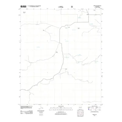
2011 Map of Pinon
USGS Topo · Published 2011About this map
Piñon stands as the primary settlement in this high-desert ranching landscape of southern New Mexico, where water management defines the pattern of human activity. The presence of numerous named earthen structures, such as Dipping Vat Tank, School Section Tank, and Resley Tank, underscores the critical importance of livestock water sources in the arid high country. Family names are etched into the geography through holdings like Sowell Ranch, Havens Ranch, and Coupland Ranch, reflecting the area's ongoing identity as a ranching hub.
Find a feature on this map
30 named features on this map. Tap any name to fly to it.
Don’t see what you’re looking for? This feature index may not catch every label — zoom into the map to look around manually.
Map Details
Editions of this 2011 Pinon Map
This is the sole edition of this map. No revisions or reprints were ever made.
Other maps of this area

1954 · Carlsbad
USGS Topo · 1:250,000

1958 · Carlsbad
USGS Topo · 1:250,000

1963 · Cornucopia Canyon
USGS Topo · 1:24,000

1963 · Indian Draw
USGS Topo · 1:24,000

1965 · Chimney Lake
USGS Topo · 1:24,000

1965 · Bear Spring
USGS Topo · 1:24,000

1965 · Surveyors Canyon
USGS Topo · 1:24,000

1965 · Avis
USGS Topo · 1:24,000

1965 · Pinon
USGS Topo · 1:24,000
1965 · Cornucopia Canyon
USGS Topo · 1:24,000