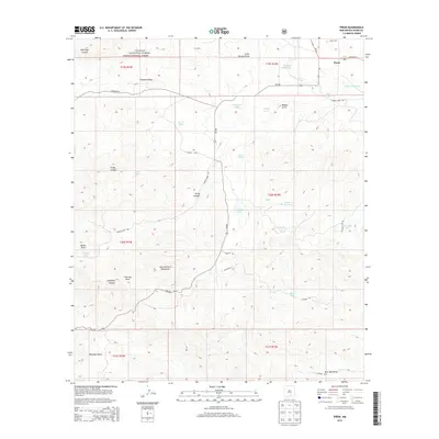
2013 Map of Pinon
USGS Topo · Published 2013About this map
Pinon stands at the intersection of NM-24 and Highway 24 in the high country of the Sacramento Mountains. This high-altitude landscape is defined by the rugged interface of the Lincoln National Forest and private ranching interests, where water management is paramount. Numerous artificial catchments and reservoirs, such as School Section Tank, Jim Godley Tank, and Richardson Lake, dot the terrain to support livestock in a region carved by deep drainage features like Gregg Canyon and Behringer Canyon. Genealogists and local historians can locate the Piñon Cem just north of the primary settlement. The map reveals a complex network of forest and county roads, including Bonita Draw Rd and Dorothy Rd, that provide access through the complex topography of draws and canyons such as Moccasin Draw and Fleming Draw.
Find a feature on this map
44 named features on this map. Tap any name to fly to it.
Don’t see what you’re looking for? This feature index may not catch every label — zoom into the map to look around manually.
Map Details
Editions of this 2013 Pinon Map
This is the sole edition of this map. No revisions or reprints were ever made.
Other maps of this area

1954 · Carlsbad
USGS Topo · 1:250,000

1958 · Carlsbad
USGS Topo · 1:250,000

1963 · Cornucopia Canyon
USGS Topo · 1:24,000

1963 · Indian Draw
USGS Topo · 1:24,000

1965 · Chimney Lake
USGS Topo · 1:24,000

1965 · Bear Spring
USGS Topo · 1:24,000

1965 · Surveyors Canyon
USGS Topo · 1:24,000

1965 · Avis
USGS Topo · 1:24,000

1965 · Pinon
USGS Topo · 1:24,000
1965 · Cornucopia Canyon
USGS Topo · 1:24,000