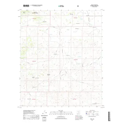
2020 Map of Pinon
USGS Topo · Published 2020About this map
Piñon serves as the central hub for this high-altitude landscape where the southern reaches of the Lincoln National Forest meet the Sacramento Mountains. The area is defined by a sophisticated network of water management features essential for ranching and settlement in this arid environment, including Richardson Lake, Shockley Lake, and numerous named catchments such as the Jim Godley Tank and Dean Tank. These features are connected by a system of roads like the Owen Prather Hwy and Stevens Draw Rd, which navigate a terrain carved by deep drainages such as Behringer Canyon, Gregg Canyon, and Chatfield Canyon. The map provides a detailed view of how human activity—from small settlements to named ranching tanks—adapts to the complex topography of Otero County's high desert and mountain transition zones.
Find a feature on this map
46 named features on this map. Tap any name to fly to it.
Don’t see what you’re looking for? This feature index may not catch every label — zoom into the map to look around manually.
Map Details
Editions of this 2020 Pinon Map
This is the sole edition of this map. No revisions or reprints were ever made.
Other maps of this area

1954 · Carlsbad
USGS Topo · 1:250,000

1958 · Carlsbad
USGS Topo · 1:250,000

1963 · Cornucopia Canyon
USGS Topo · 1:24,000

1963 · Indian Draw
USGS Topo · 1:24,000

1965 · Chimney Lake
USGS Topo · 1:24,000

1965 · Bear Spring
USGS Topo · 1:24,000

1965 · Surveyors Canyon
USGS Topo · 1:24,000

1965 · Avis
USGS Topo · 1:24,000

1965 · Pinon
USGS Topo · 1:24,000
1965 · Cornucopia Canyon
USGS Topo · 1:24,000