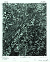
1975 Map of Pinson
USGS Topo · Published 1977About this map
Suburban development and wooded ridgelines characterize this 1975 orthophotoquad of Jefferson County, Alabama. Unlike a traditional topographic map, this imagery provides a direct overhead view of the land as it appeared in the mid-1970s, revealing the dense street networks and residential expansion concentrated in the southern portion of the sheet. The settlement of Palmerdale is visible in the northeast, positioned along the valley floor between the distinct northeast-southwest trending ridges of the Appalachian foothills. This particular study was produced through a collaboration between the Geological Survey and the Soil Conservation Service, offering a clear record of land use and vegetation patterns during a period of significant growth. The high-contrast imagery highlights the corridors of transportation and clearing that contrast sharply with the shadowed, heavily timbered slopes of the surrounding hills.
Find a feature on this map
1 named feature on this map. Tap any name to fly to it.
Don’t see what you’re looking for? This feature index may not catch every label — zoom into the map to look around manually.
Map Details
Editions of this 1975 Pinson Map
This is the sole edition of this map. No revisions or reprints were ever made.
Other maps of this area

1889 · Birmingham
USGS Topo · 1:125,000

1892 · Birmingham
USGS Topo · 1:125,000

1895 · Birmingham
USGS Topo · 1:125,000

1904 · Birmingham Coal District
USGS Topo · 1:62,500

1905 · Leeds
USGS Topo · 1:62,500

1906 · Birmingham Special
USGS Topo · 1:62,500

1907 · Birmingham
USGS Topo · 1:125,000

1907 · Leeds
USGS Topo · 1:62,500

1951 · Warrior
USGS Topo · 1:24,000

1953 · Birmingham
USGS Topo · 1:250,000