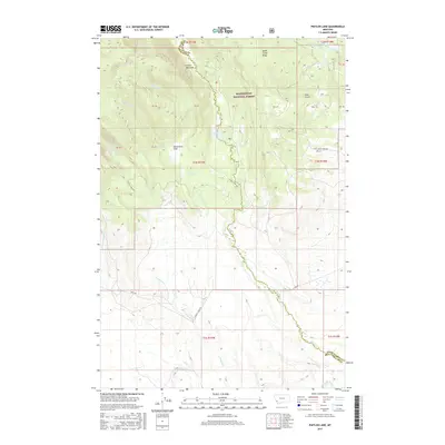
2017 Map of Pintler Lake
USGS Topo · Published 2017About this map
Beaverhead National Forest defines the upper elevations of this Montana landscape, where the primary drainage of Pintler Creek flows south from Pintler Lake. The terrain is characterized by high-altitude features like Pintler Meadows and the steep descent of Pintler Falls. The county boundary between Deer Lodge County and Beaverhead County snakes through the topography, tracing the high ridges above Mudd Creek and York Gulch. At the southern edge of the survey, the terrain opens as it approaches the Big Hole River valley. While largely a wilderness area, the network of service roads such as Mudd Creek Road and Howell Creek Road indicates the accessibility of these back-country locations for recreation and resource management. Small mountain lakes like Lion Lake and localized openings such as McCormick Park provide specific landmarks within the dense forest cover.
Find a feature on this map
35 named features on this map. Tap any name to fly to it.
Don’t see what you’re looking for? This feature index may not catch every label — zoom into the map to look around manually.
Map Details
Editions of this 2017 Pintler Lake Map
This is the sole edition of this map. No revisions or reprints were ever made.
Other maps of this area

1955 · Dillon
USGS Topo · 1:250,000

1957 · Dillon
USGS Topo · 1:250,000

1958 · Dillon
USGS Topo · 1:250,000

1962 · Dillon
USGS Topo · 1:250,000

1962 · Mud Lake
USGS Topo · 1:24,000

1962 · Pine Hill
USGS Topo · 1:24,000

1962 · Pintlar Lake
USGS Topo · 1:24,000

1962 · Proposal Rock
USGS Topo · 1:24,000
1962 · Long Peak
USGS Topo · 1:24,000
1962 · Warren Peak
USGS Topo · 1:24,000