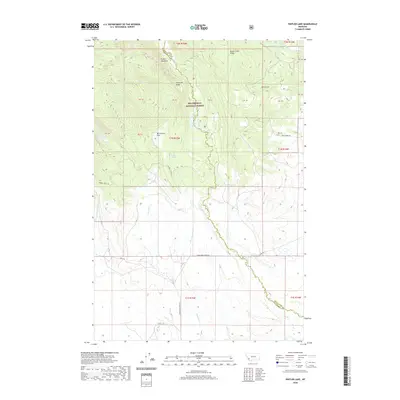
2020 Map of Pintler Lake
USGS Topo · Published 2020About this map
Beaverhead National Forest encompasses this high-altitude landscape where the boundary between Deer Lodge and Beaverhead counties follows the heights of the Anaconda Range. The map reveals a complex drainage system where Pintler Cr flows south from Pintler Lake and the dramatic Pintler Falls, while Mudd Creek and its various forks originate near Mudd Creek Ridge to the northeast. A high-elevation clearing at McCormick Park sits near the headwaters of McCormick Cr, illustrating the isolated nature of these mountain meadows. The road network is limited to rugged access routes such as Mudd Creek Rd and Howell Creek Rd, which provide the only managed paths into this remote wilderness area near Lion Lake.
Find a feature on this map
37 named features on this map. Tap any name to fly to it.
Don’t see what you’re looking for? This feature index may not catch every label — zoom into the map to look around manually.
Map Details
Editions of this 2020 Pintler Lake Map
This is the sole edition of this map. No revisions or reprints were ever made.
Other maps of this area

1955 · Dillon
USGS Topo · 1:250,000

1957 · Dillon
USGS Topo · 1:250,000

1958 · Dillon
USGS Topo · 1:250,000

1962 · Dillon
USGS Topo · 1:250,000

1962 · Mud Lake
USGS Topo · 1:24,000

1962 · Pine Hill
USGS Topo · 1:24,000

1962 · Pintlar Lake
USGS Topo · 1:24,000

1962 · Proposal Rock
USGS Topo · 1:24,000
1962 · Long Peak
USGS Topo · 1:24,000
1962 · Warren Peak
USGS Topo · 1:24,000