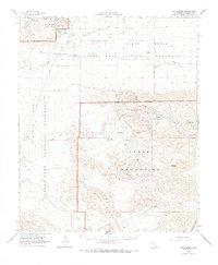
1963 Map of Pinto Basin
USGS Topo · Published 1968About this map
Mining operations and desert hydrology define this 1963 survey of the Pinto Basin and Eagle Mountains. Located within the boundaries of Joshua Tree National Monument, the landscape is marked by a high concentration of mineral prospects, including the Black Eagle Mine, Rusty Gold Mine, and the evocatively named Rainbows End Mine. These sites, alongside the Storm Jade Mine and Mystery Mine, illustrate a mid-century period when remote claims were still active or prominently documented in the California desert.
Find a feature on this map
42 named features on this map. Tap any name to fly to it.
Don’t see what you’re looking for? This feature index may not catch every label — zoom into the map to look around manually.
Map Details
Editions of this 1963 Pinto Basin Map
2 editions found
Other maps of this area

1940 · Cottonwood Spring
USGS Topo · 1:62,500

1940 · Canyon Spring
USGS Topo · 1:62,500

1942 · Amboy
USGS Topo · 1:250,000

1943 · Amboy
USGS Topo · 1:250,000

1943 · Cadiz Valley
USGS Topo · 1:62,500

1943 · Canyon Spring
USGS Topo · 1:62,500

1943 · Coxcomb Mountains
USGS Topo · 1:62,500

1943 · Pinkham Well
USGS Topo · 1:62,500

1944 · Cottonwood Spring
USGS Topo · 1:62,500

1944 · Pinkham Well
USGS Topo · 1:62,500