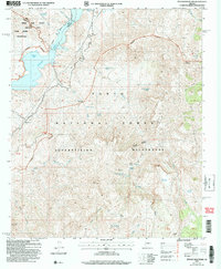
2004 Map of Pinyon Mountain
USGS Topo · Published 2007About this map
The boundary between Maricopa and Gila counties runs through this landscape of high ridges and protected interior lands, anchored by the Tonto National Forest. Much of the territory is dedicated to conservation, split between the Four Peaks Wilderness in the north and the Superstition Wilderness to the south. Central to this area is the Maricopa County Three Bar State Wildlife Area, which provides a buffer for the diverse species found in this arid environment.
Find a feature on this map
37 named features on this map. Tap any name to fly to it.
Don’t see what you’re looking for? This feature index may not catch every label — zoom into the map to look around manually.
Map Details
Editions of this 2004 Pinyon Mountain Map
This is the sole edition of this map. No revisions or reprints were ever made.
Other maps of this area

1900 · Florence
USGS Topo · 1:125,000

1902 · Florence
USGS Topo · 1:125,000

1907 · Roosevelt
USGS Topo · 1:125,000

1909 · Four Peaks
USGS Topo · 1:125,000

1912 · Roosevelt
USGS Topo · 1:125,000

1948 · Superior
USGS Topo · 1:62,500

1948 · Iron Mountain
USGS Topo · 1:24,000
1948 · Haunted Canyon
USGS Topo · 1:24,000

1949 · Iron Mountain
USGS Topo · 1:24,000
1949 · Haunted Canyon
USGS Topo · 1:24,000