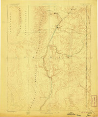
1885 Map of Pioche
USGS Topo · Published 1906About this map
Pioche serves as the focal point of this nineteenth-century reconnaissance of eastern Nevada, situated near Mt Ely at the northern reaches of Meadow Valley. The settlement pattern follows the drainage systems and valley floors, with Bullionville and Panaca established along the watercourse as early hubs of activity. The surrounding landscape is defined by a series of north-south oriented ranges, including the Highland Mountains and the Needle Mountains, which separate the expansive Desert Valley from the Nevada-Utah boundary line.
Find a feature on this map
20 named features on this map. Tap any name to fly to it.
Don’t see what you’re looking for? This feature index may not catch every label — zoom into the map to look around manually.
Map Details
Editions of this 1885 Pioche Map
4 editions found
Other maps of this area

1885 · St. George
USGS Topo · 1:250,000

1885 · Pioche
USGS Topo · 1:250,000

1886 · Saint Thomas
USGS Topo · 1:250,000

1886 · Mt. Trumbull
USGS Topo · 1:250,000

1886 · Pioche
USGS Topo · 1:250,000

1891 · St. George
USGS Topo · 1:250,000

1892 · Mt. Trumbull
USGS Topo · 1:250,000

1893 · Saint Thomas
USGS Topo · 1:250,000

1907 · Las Vegas
USGS Topo · 1:250,000

1908 · Las Vegas
USGS Topo · 1:250,000