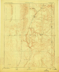
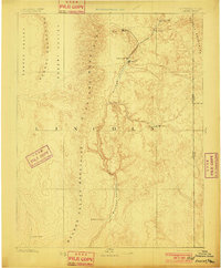
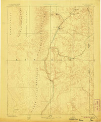
1885 Map of Pioche
USGS Topo · Published 1914About this map
The silver mining district centered around Pioche defines this 1885 reconnaissance survey of eastern Lincoln County. Published during a period of significant mineral extraction, the map illustrates the early industrial footprint of the region, specifically at Bullionville and the nearby agricultural settlement of Panaca. The topography is defined by the north-south alignment of the Pahroc Mountains and the Highland Mountains, with the Meadow Valley providing a natural corridor for movement through the arid terrain. While much of the landscape is dominated by expansive basins like Desert Valley, localized water sources such as Hackberry Spring and Coyote Spring appear as critical landmarks for travelers and early settlers. The eastern edge of the sheet documents the Nevada-Utah boundary line, situated amidst the high elevations of the Needle Mountains.
Find a feature on this map
20 named features on this map. Tap any name to fly to it.
Don’t see what you’re looking for? This feature index may not catch every label — zoom into the map to look around manually.
Map Details
Editions of this 1885 Pioche Map
4 editions found
Other maps of this area

1885 · St. George
USGS Topo · 1:250,000

1885 · Pioche
USGS Topo · 1:250,000

1886 · Saint Thomas
USGS Topo · 1:250,000

1886 · Mt. Trumbull
USGS Topo · 1:250,000

1886 · Pioche
USGS Topo · 1:250,000

1891 · St. George
USGS Topo · 1:250,000

1892 · Mt. Trumbull
USGS Topo · 1:250,000

1893 · Saint Thomas
USGS Topo · 1:250,000

1907 · Las Vegas
USGS Topo · 1:250,000

1908 · Las Vegas
USGS Topo · 1:250,000