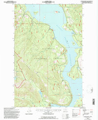
1994 Map of Pioneer Ridge
USGS Topo · Published 1997About this map
Hungry Horse Reservoir dominates the landscape in this 1994 revision, showing the high-water line at an elevation of 3,560 feet. The rugged topography of the Flathead National Forest is defined by the steep ascent of Pioneer Ridge, where the Pioneer Lookout stands as a focal point for forest management. This survey by the U.S. Forest Service highlights the recreational and administrative infrastructure of the late 20th century, including the Jewel Basin Hiking Area and the Anna Creek Work Station.
Find a feature on this map
37 named features on this map. Tap any name to fly to it.
Don’t see what you’re looking for? This feature index may not catch every label — zoom into the map to look around manually.
Map Details
Editions of this 1994 Pioneer Ridge Map
This is the sole edition of this map. No revisions or reprints were ever made.
Other maps of this area

1914 · Nyack
USGS Topo · 1:125,000

1958 · Quintonkon
USGS Topo · 1:24,000

1958 · Felix Peak
USGS Topo · 1:24,000

1960 · Cut Bank
USGS Topo · 1:250,000

1963 · Cut Bank
USGS Topo · 1:250,000

1964 · Cut Bank
USGS Topo · 1:250,000
1964 · Jewel Basin
USGS Topo · 1:24,000

1964 · Pinnacle
USGS Topo · 1:24,000
1964 · Nyack SW
USGS Topo · 1:24,000
1964 · Crater Lake
USGS Topo · 1:24,000