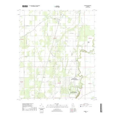
2018 Map of Pioneer
USGS Topo · Published 2018About this map
Poverty Point National Monument anchors the southeastern portion of this landscape, marking a site of immense historical significance along the banks of Bayou Macon. This 2018 survey reveals a terrain defined by complex hydrology, where ancient alluvial patterns are traced by Alligator Bayou, Caney Glade Bayou, and Long Lake Bayou. The settlement of Pioneer serves as a local hub near the northern border, while the smaller hamlets of Floyd, Darnell, and Gowen are connected by a network of rural routes such as Bayou Macon Cemetery Rd and Dummy Line Rd. Local heritage is preserved in sites like Wilson Cem and Bethany Cem, while the Bayou Meadows Airport represents more contemporary regional infrastructure. The map illustrates the persistent relationship between the agricultural West Carroll Parish lowlands and the meandering waterways that have dictated human habitation for millennia.
Find a feature on this map
65 named features on this map. Tap any name to fly to it.
Don’t see what you’re looking for? This feature index may not catch every label — zoom into the map to look around manually.
Map Details
Editions of this 2018 Pioneer Map
This is the sole edition of this map. No revisions or reprints were ever made.
Other maps of this area

1909 · Baxter Bayou
USGS Topo · 1:24,000

1911 · Baxter Bayou
USGS Topo · 1:24,000

1914 · Baxter Bayou
USGS Topo · 1:31,680

1935 · Hurricane
USGS Topo · 1:62,500

1935 · Oak Grove
USGS Topo · 1:62,500

1935 · Bonita
USGS Topo · 1:62,500

1955 · Jackson
USGS Topo · 1:250,000

1958 · Oak Grove
USGS Topo · 1:62,500

1958 · Hurricane
USGS Topo · 1:62,500

1958 · Bonita
USGS Topo · 1:62,500