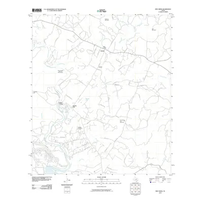
2010 Map of Pipe Creek
USGS Topo · Published 2010About this map
The Medina River carves a deep path through this Texas Hill Country landscape, leading into the northern reaches of Medina Lake near the community of Lakehills. This early 21st-century survey documents a region defined by residential expansion and aviation, with both the Taylors Saddle Mountain Ranch Airport and the Medina River Ranch Airport serving local ranching estates. The settlement of Pipe Creek sits at a crossroads in the north, near the Pipe Creek Cemetery, while the southern area shows dense residential plating near the lakeshore. Distinctive geographic landmarks such as the Wonder Hole and Smoothing Iron Mountain stand out amidst the drainage networks of Red Bluff Creek and Dry Hollow Creek, illustrating the transition from open ranchland to lakeside developments.
Find a feature on this map
73 named features on this map. Tap any name to fly to it.
Don’t see what you’re looking for? This feature index may not catch every label — zoom into the map to look around manually.
Map Details
Editions of this 2010 Pipe Creek Map
This is the sole edition of this map. No revisions or reprints were ever made.
Other maps of this area

1954 · San Antonio
USGS Topo · 1:250,000

1956 · Comfort
USGS Topo · 1:62,500

1956 · Bandera
USGS Topo · 1:62,500

1956 · Medina Lake
USGS Topo · 1:62,500

1956 · Center Point
USGS Topo · 1:62,500

1957 · San Antonio
USGS Topo · 1:250,000

1964 · Bandera
USGS Topo · 1:24,000

1964 · Timber Creek
USGS Topo · 1:24,000

1964 · Medina Lake
USGS Topo · 1:24,000
1964 · Ranger Creek
USGS Topo · 1:24,000