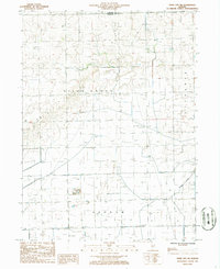
1986 Map of Piper City NE
USGS Topo · Published 1986About this map
The rural intersection of Milks Grove, Ashkum, and Chebanse townships is captured here during the mid-1980s. This agricultural landscape in East Central Illinois is defined by a rigorous grid of drainage ditches and section roads, showing the evolution of the Grand Prairie into productive farmland. The hydrology is centered on Langan Creek, which winds through the southeastern portion of the quadrangle. Significant local infrastructure includes the Berns Landing Strip, reflecting the role of private aviation in managing these large agricultural holdings. Signs of localized industry and early settlement are present via a Gravel Pit, a Well, and a small Cem located near the township boundaries. These features provide a clear view of the specialized land use in the Kankakee and Iroquois County borderlands prior to further modern consolidation.
Find a feature on this map
9 named features on this map. Tap any name to fly to it.
Don’t see what you’re looking for? This feature index may not catch every label — zoom into the map to look around manually.
Map Details
Editions of this 1986 Piper City NE Map
This is the sole edition of this map. No revisions or reprints were ever made.
Other maps of this area

1922 · Kankakee
USGS Topo · 1:62,500

1923 · Herscher
USGS Topo · 1:62,500

1924 · Kankakee
USGS Topo · 1:62,500

1925 · Herscher
USGS Topo · 1:62,500

1944 · Piper City
USGS Topo · 1:48,000

1944 · Gilman
USGS Topo · 1:62,500

1946 · Gilman
USGS Topo · 1:62,500

1947 · Piper City
USGS Topo · 1:62,500

1953 · Chicago
USGS Topo · 1:250,000

1953 · Danville
USGS Topo · 1:250,000