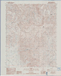
1987 Map of Piper Peak
USGS Topo · Published 1987About this map
Piper Peak 9450 anchors this survey of the high desert terrain within the Silver Peak Range. The landscape is defined by its verticality and water scarcity, with drainage networks like Icehouse Canyon, McAfee Canyon, and Piper Canyon cutting deep paths through the high country toward the Fish Lake Valley floor. This 1980s provisional map reveals a world of active and former extraction efforts, indicated by numerous Prospects and a Borrow Pit near the valley edge.
Find a feature on this map
15 named features on this map. Tap any name to fly to it.
Don’t see what you’re looking for? This feature index may not catch every label — zoom into the map to look around manually.
Map Details
Editions of this 1987 Piper Peak Map
This is the sole edition of this map. No revisions or reprints were ever made.
Other maps of this area

1898 · Silver Peak
USGS Topo · 1:125,000

1900 · Silver Peak
USGS Topo · 1:125,000

1908 · Lida
USGS Topo · 1:250,000

1913 · Lida
USGS Topo · 1:250,000

1917 · White Mountain
USGS Topo · 1:125,000

1947 · Mariposa
USGS Topo · 1:250,000

1948 · Mariposa
USGS Topo · 1:250,000

1954 · Goldfield
USGS Topo · 1:250,000

1955 · Goldfield
USGS Topo · 1:250,000

1957 · Mariposa
USGS Topo · 1:250,000