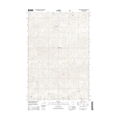
2014 Map of Piquett Mountain
USGS Topo · Published 2014About this map
Bitterroot National Forest encompasses this high-altitude landscape of the Sapphire Range, dominated by peaks like Wiles Peak and Piquett Mtn. The drainage patterns here are distinct, with numerous seasonal and perennial creeks such as Slate Cr and Angle Cr carving deep gulches into the terrain. For those interested in the area's hydrology, the presence of Shelf Lake, Slate Lake, and Piquett Lake in the northern reaches shows the glacial origins of these mountain basins. High ridges like Rombo Mtn and Quartzite Mtn define the watershed boundaries between Ravalli County and the surrounding forest lands. Transportation is sparse in this protected wilderness, primarily limited to corridors like Overwhich Rd which skirts the edges of Mill Gulch and Meadow Gulch. This 2014 survey documents the wilderness character of the Bitterroot before any significant contemporary shifts in forest management or road access.
Find a feature on this map
25 named features on this map. Tap any name to fly to it.
Don’t see what you’re looking for? This feature index may not catch every label — zoom into the map to look around manually.
Map Details
Editions of this 2014 Piquett Mountain Map
This is the sole edition of this map. No revisions or reprints were ever made.
Other maps of this area

1956 · Elk City
USGS Topo · 1:250,000

1960 · Elk City
USGS Topo · 1:250,000

1960 · Painted Rocks Lake
USGS Topo · 1:62,500

1960 · Piquett Mountain
USGS Topo · 1:62,500

1964 · Boulder Peak
USGS Topo · 1:24,000

1964 · Piquett Creek
USGS Topo · 1:24,000

1965 · Medicine Hot Springs
USGS Topo · 1:24,000
1991 · Piquett Mountain
USGS Topo · 1:24,000
1991 · Henderson Ridge
USGS Topo · 1:24,000
1991 · Painted Rocks Lake
USGS Topo · 1:24,000